
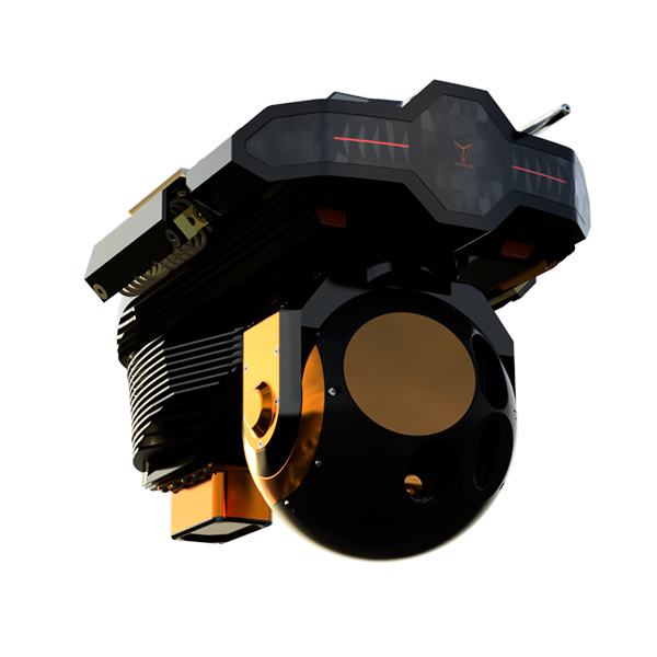
Low SWaP Gimbal System
Add value for your wildfire, powerline, and energy customers with a low Size, Weight and Power gimbal system with visual and infrared capabilities.
Equip helicopters with real-time AI, data capture, and analytics to transform wildfire response and geospatial intelligence.
Supercharge your fleet with the world's first Airborne AI for helicopters.


VoxVison is a multi-sensor AI edge-computing platform that acts as an AI crewmember, assisting crews to perform missions and augmenting situational awareness and mission safety.
VoxVision equipped helicopters arrive at wildfires ready for thermal scans, mapping, and environmental monitoring.
Helicopters operate in a regime between high altitude/satellites and low level UAVs, providing a massive dataset opportunity for understanding the earth and environment.

The VoxVision platform will allow a seamless experience for data users and helicopter operators to coordinate data acquisition.

Increase the utility of your fleet for your customers, understand your fleet better, automate time-consuming tasks, and open new revenue opportunities through automated data collection.
Add value for your wildfire, powerline, and energy customers with a low Size, Weight and Power gimbal system with visual and infrared capabilities.

Understand aircraft usage, health, and costs with deep-learning powered insights.

Computer vision and other sensors can provide obstacle and other warnings to aid crew awareness.
Unlock new functionalities with simple software updates as we develop them and as new technologies become available.

The helicopter transforms into a data collection and processing platform, adding value for customers, with seamless delivery through our platform.
Data on demand without leaving the office, powered by the Voxelis Cloud.

GEM is a curated collection of geospatial data collected by our VoxVision partners, and our proprietary deep-learning based earth and atmosphere models.


The helicopter industry faces a growing shortage of the most experienced pilots, which will impact our ability to fight wildfire in the future.
VoxVision and VoxNav will also serve as the training platform for Voxelis AI Pilot - the world's most advanced AI helicopter pilot - to ensure our industry's ability to protect our forests and the environment remains and improves in the future.


.svg)
